
The traditional map of the world, known as the Mercator map, may be the most often seen image of our planet but it is also considered highly inaccurate because Antarctica and Greenland are greatly distorted.
Now, a Japanese artist and architect believes he has solved this 447 year old problem with an ‘origami map’ that represents landmasses and seas as accurately as possible.
To create the perfectly proportioned map, Hajime Narukawa divided the spherical globe into 96 triangles that are flattened and transferred to a tetrahedron.
This allows the image to be ‘unfolded’ into a rectangle while still maintaining an area’s proportions.
Scroll down for video
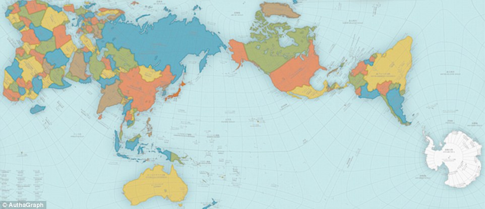
A Japanese architect has created what may be the most accurate map of the world. Hajime Narukawa used a new map (main) making method called AuthaGraph that divides the globe into 96 triangles, transfers them a tetrahedron and unfold it to be a rectangle – all while keeping the landmasses and seas proportioned.
Narukawa’s map was awarded the coveted Grand Award of Japan’s most well-known design award during the Good Design Award for 2016 – last year a personal mobility chair won and the year before it was a robotic arm, reports Spoon-Tamago.
Gerardus Mercator is widely known for creating the most generally accepted map of the world, and also created the term ‘atlas’ to describe a collection of maps.
In 1569, Mercator introduced his map of the world using a method called Mercator projection.
This process projected the world onto a cylinder in a way that all the parallels of latitude have the same length as the equator, used especially for marine charts and certain climatological maps.
And although it is used throughout the world, it is known for being greatly inaccurate – it was originally designed to help sailors navigate the world.
To give the world a more accurate depiction, Narukawa created a different method that aims to create a map where all the land areas and seas are accurately sized.
‘If it doesn’t sell, it isn’t creative‘ – David Ogilvy


